

County Transportation Plan
A four year process to update the St. Mary’s County Transportation Plan is coming to a close after a public hearing was held November 18th. Held at 9:15 a.m., there were no speakers.
In June 2021, the County Commissioners approved the budget for $120,000 towards the transportation plan update. The Department of Public Works & Transportation (DPWT) hired Brudis & Associates, a consulting firm, to complete the task.
The consultant used the 2006 Transportation Plan as a basis, and considered others like the 2010 Comprehensive Plan, the Calvert-St. Mary’s Metropolitan Planning Organization’s (C-SMMPO) 2045 Long Range Transportation Plan, the 2040 Maryland Transportation Plan, and other documents. Public input was collected in 2022 from 149 respondents who completed a ten question survey. Additionally, Brudis & Associates spoke with the directors of three relevant county departments.
Creating the plan is supposed to “result in lower future transportation operational and improvement costs, increased traffic safety, decreased air pollution, and a higher quality of life” for residents. Focusing on multimodal transportation options, the plan sets “goals, priorities, and funding strategies to guide the county’s transportation infrastructure investments.”
Data is the most valuable product in this report. Over 1600 roads, more than 1300 lane miles, are part of the county system. That doesn’t include state managed roads, which make up a large portion of local infrastructure. Traffic volumes, crash data, plans for cycling networks, and public transportation options are also covered. Interestingly, the document mentions plans to move the St. Mary’s Transit (STS) transfer station from Tulagi Place to California Boulevard citing NAS/PAX flyover restrictions at the current location.


In the next twenty years, traffic congestion will become critical. “By 2045, the model forecasts roadway traffic to stress the capacity of nearly the entire MD 235, MD 5, and MD 4 corridors during peak periods,” the report states. Levels of service (LOS) on major arterial roadways like MD 4, 5, 234, 235, 237, and 246 will decrease to an “F” rating as traffic volume increases. Projections show areas like California and Leonardtown could see 20,000 and 40,000 additional vehicles per day, respectively, while volume along Route 5 is expected to increase by at least 50,000 vehicles.
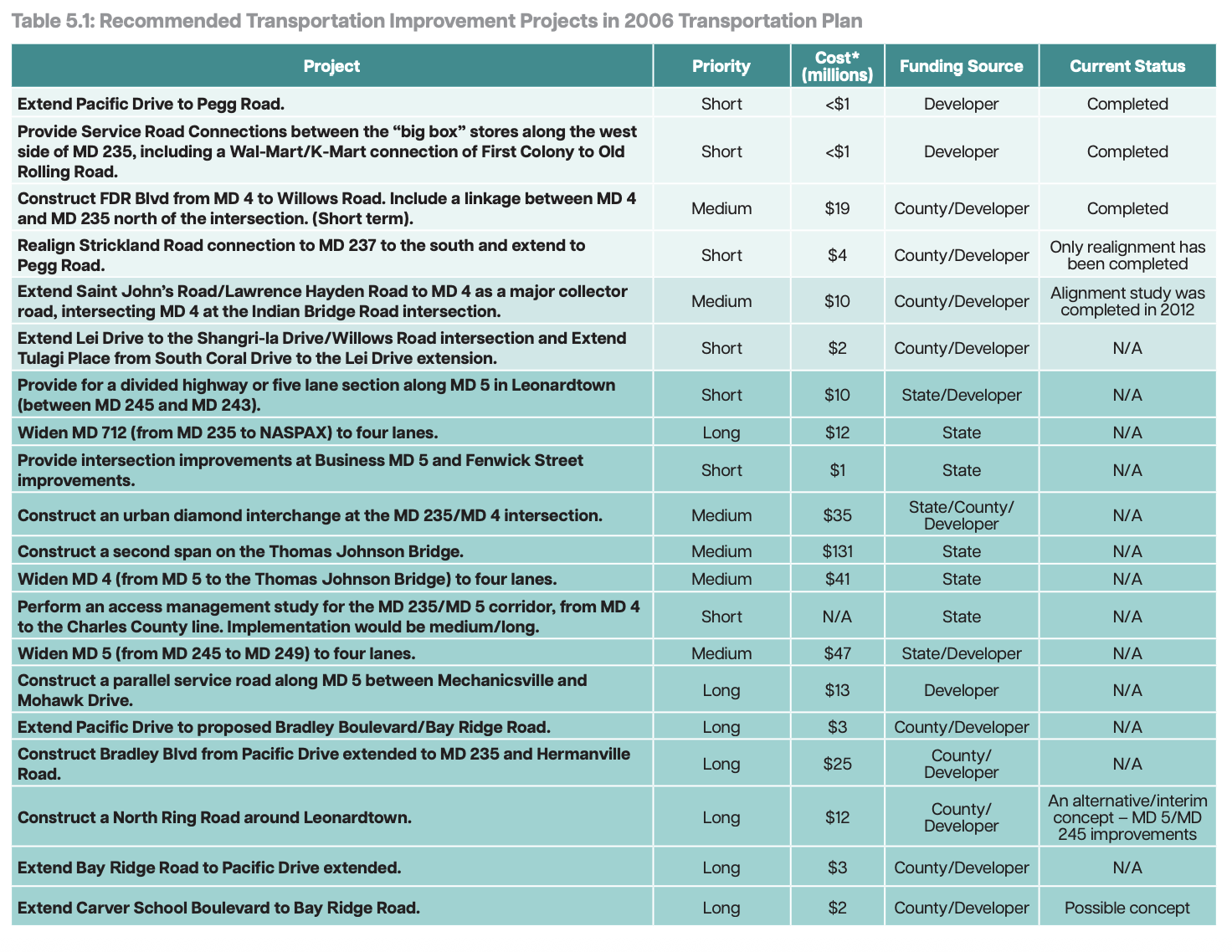
Recommendations for infrastructure improvements show investments needed to alleviate future traffic congestion. Table 5.1, seen above, is a list of projects from the 2006 Transportation Plan. Costs listed are in 2006 numbers, which projected $131M cost for a second span of the Thomas Johnson Bridge. A bridge upgrade project now estimated to cost more than $500M. Major upgrades rely on funding from the State or a private developer.

The report expects nearly $300M spent across three projects in 2026, including the MD 5/MD 246 intersection improvements and road widening, constructing an interchange at MD 4/MD 235, and widening MD 4 to four lanes from 235 to the bridge. Funding is identified in 2030 to construct a new, four lane Thomas Johnson bridge. The report lists these projects from the C-SMMPO’s Long Range Transportation Plan which was developed in 2020. Budgets were created under Governor Larry Hogan, whose budget fully funded hundreds of millions of dollars in the out years despite no funding having actually been identified or allocated.
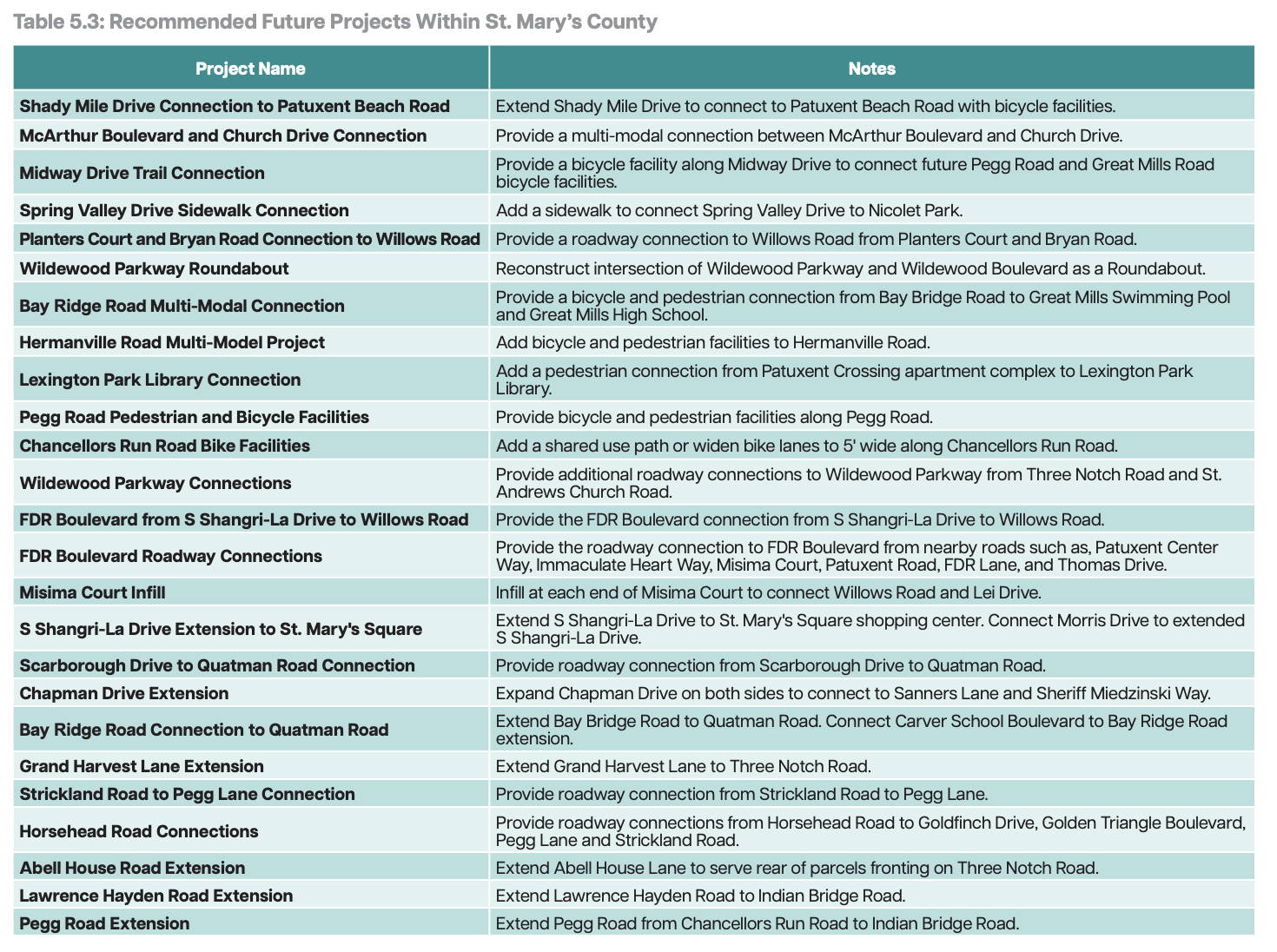
A list of 25 recommended future projects for St. Mary’s County managed roads are listed in Table 5.3. No costs are listed, but the county will probably have to foot the bill through capital improvement projects.
The plan lacks specific action items, and doesn’t cover several improvement projects that have been identified in the last several years. For example, nothing is mentioned about intersections like MD 5 and Willows Road or FDR Blvd and MD 235. Developers have paid fees towards the costs of signalizing these intersections, funds which are held by the county until the project’s budget is satisfied. It’s unclear where or how this money is accounted for–whether it's kept in the county’s general fund or a specific account for these improvements.


Other notable recommendations are focused on expanding pedestrian and cycle facilities, connecting roads to draw traffic away from major highways, and improving traffic safety along busy roads. Some example:
Complete widening of Route 5 through Leonardtown from MD 243 to MD 245;
Widening Route 5 to six lanes from Route 6 to the Charles County line through Charlotte Hall;
North County Connector between Golden Beach Road and New Market Turner Road;
“North Ring” around Leonardtown
Extending and creating connections between:
Tulagi Place and Bay Ridge Road
Lawrence Hayden Road to Indian Bridge Road
Pegg Road to Indian Bridge Road
Pacific Drive to Bay Ridge Road and Bradley Boulevard
Bradley Boulevard to MD 235 and Hermanville Road
Comments about the Transportation Plan are accepted via email, csmc@stmaryscountymd.gov, through November 25, 2025.
—————
Keeping you informed is a full time commitment, alongside my 9-to-5 and volunteer responsibilities. Not only is it a time commitment, but a financial one too. Informed St. Mary’s remains paywall free for everyone with your support. Donate here to support this important work.