

Town Plans Annexation

Public Hearing To Be Scheduled
Plans to expand the Town limits by annexing three properties, more than 70 acres, are moving forward after approval was granted by the Town Council on October 14. The only municipality in St. Mary’s County, Leonardtown has slowly expanded its borders over the years through this process. All properties are within the Town’s municipal growth boundary, approved with the 2025 Comprehensive Plan.
David and Nancy Hall, of Bushwood, have petitioned for annexation of approximately 16 acres at 40985 Greenhill Lane. The property is across Route 5 from the Shops at Breton Bay shopping center. Part of the Greenwood Hills Subdivision, the wooded property is behind two parcels that front Route 5, one of which is also owned by the Halls, and are already within town limits.
According to the town’s staff report, a storage shed is the only building on the lot, though a driveway runs through the land to a home on a neighboring parcel. The report also notes the property contains highly erodible soils and wetland areas. Presently, the land is zoned as Rural Preservation under the county’s zoning ordinance. The report notes that “five acres on the southern portion are subject to Transferable Development Rights, and the northern portion contains protected open space.”
If annexed, the zoning would align with Leonardtown’s zoning regulations, making it Commercial-Highway. The proposed use on the staff report is “Commercial (Auto Services).” Mayor Dan Burris said the owners have been leasing space for their business, D&G Kustoms, but intend to move to this property. “The intent of this annexation is to facilitate future development consistent with the Town’s Comprehensive Plan while preserving rural character,” states a letter from the Hall’s lawyer.

Further south, off Cedar Lane Road, are two other properties seeking annexation by the Town. A three acre parcel beside Cedar Lane Senior Living Community, owned by Randall Johnston, is surrounded on three sides by land already within Town limits. One property, about 20 acres, is owned by the Leonardtown Volunteer Fire Department and will likely be the location of a new firehouse in the future. Laschelle McKay, Town Administrator, spoke with Mr. Johnston who said he lives on the property. If annexed, the property will transfer from county zoning category Rural Limited to Rural-Single Family under the Town’s zoning.
Johnston’s annexation petition is paired with one for a larger, 52 acre parcel across the street that was once part of Ellenborough Farm. Rodney Gertz, of Quality Built Homes, Inc (QBHI), is the applicant according to the town’s staff report. The property, currently county zoned for Residential Low Density, would become Planned Urban Development (PUD) - Residential once within town limits. The staff report states “all large farm parcels are PUD within the Town.” PUDs are generally large neighborhood developments–think Clark's Rest, Leonard’s Grant, Meadows at Town Run.
A concept plan showing a mix of residential dwelling types exists, and town staff is working with the applicant to develop the plan. QBHI previously developed the Meadows at Town Run neighborhood, and is in the process of building out the second phase.
All annexations are reviewed by the Town’s Planning & Zoning Board who will approve the Town’s zoning as it applies to the properties. Then, the cases head to public hearing before a decision is made by the Town Council. The public hearing date has not yet been released.

Image from Leonardtown’s Comprehensive Plan
Leonardtown’s Comprehensive Plan shows identified areas for expansion, via annexation, which increases Town’s tax base to bring in additional revenue. In the image above, the red area represents the Municipal Growth Boundary. Nearly the entirety of the old Mattingly Farm, stretching along Cedar Lane Road all the way to St. John’s Road is shaded in red. Potato Hill Farm, off Maypole Road, is also shaded red. If annexed these areas would likely become PUD-Residential, which means more homes. Land along Route 5 going past Route 234, would extend the commercial zone further north.
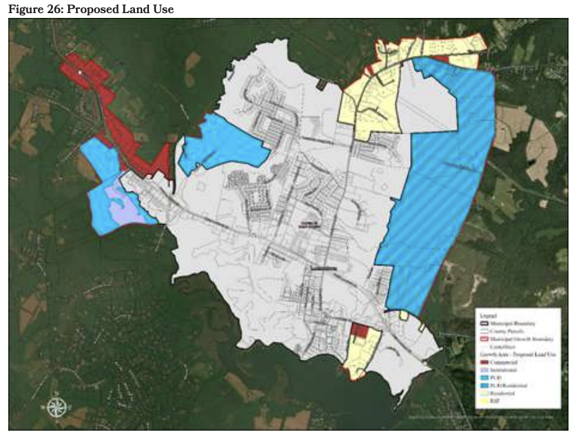
Image from Leonardtown’s Comprehensive Plan
The map above shows color-coded expansion plans, where the blue areas are PUD, the yellow Residential, the red Commercial, and the purple Institutional uses. Below, the chart lists the breakout of almost 1,400 acres that could eventually become part of Leonardtown.

Image from Leonardtown’s Comprehensive Plan
——————
Keeping you informed is a full time commitment, alongside my 9-to-5 and volunteer responsibilities. Not only is it a time commitment, but a financial one too. Informed St. Mary’s remains paywall free for everyone with your support. Donate here to support this important work.